 |
|
![]()
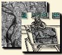
The method proposed by BESSETTES and DESACHY intends to extract and classify urban areas from remote sensing images by means of combination of an edge detector and a classification algorithm. This study improved the urban area extraction algorithm by defining a fuzzy method of urban/non-urban classification.
The algorithm is divided into two main steps:
On SPOT images, the buildings appear as small rectangles from 1 to 16 pixels. The idea lies in the detection of the angles of buildings, then in the gathering of zones with strong density of angles, to recreate the urban zones.
A SOBEL gradient operator is used horizontally and vertically on the image. The two resulting images make it possible to calculate the angles formed by the gradient vectors.
For a given pixel, the angles formed with its eight neighbours are calculated. Starting from the fact that a building angle is a right angle, a membership function expresses how much a angle looks like a right angle and therefore how much it is likely to be the angle of a building. The expression is given by:
 |
with:
The new value of the pixel will be the average of the values obtained for its eight neighbours. The image thus obtained is then filtered by a median filter.
The original image is then segmented into regions by means of the ISEF filter, followed by a hysteresis thresholding, then by an edge closing. The small regions are finally merged according to their average radiometry.
Each region defines a sample in the image of membership to angles. The
samples make it possible to calculate by dichotomy a threshold to delimit
the classes ``urban'' and ''non-urban'', as well as possible. The value
of this threshold makes it possible to obtain areas of which the number
of urban pixels is higher than ![]() ,
and others of which the number of non-urban pixels is higher than
,
and others of which the number of non-urban pixels is higher than ![]() .
The final value of the threshold is calculated starting from the histograms
of the most urban area and the least urban.
.
The final value of the threshold is calculated starting from the histograms
of the most urban area and the least urban.
To obtain a less noisy binary image, the regions which are not sufficiently homogeneous are burst according to two classes. Then they are merged again: urban with urban, non-urban with non-urban.
The final result gives a binary mask of the urban areas.