Deceti.jpg (13851 bytes)

MoreLeft.GIF (555 bytes)

Left.GIF (643 bytes)  Right.GIF (612 bytes)


Methodology


The appropriate digital geometric and radiometric preprocessing of the above satellite remote sensing images, as well as some specific processing have been carried out and the following value added images were produced: the most appropriate color composites for natural resource inventories of the region, the classification of land use and maps of the relevant changes in time, the maps of slopes and aspects of the Metsovo Province.


12-9.gif (68669 bytes)


3, 2,1 (R, G, B) True colour composites of Landsat 5 TM, of 1993, 1990, 1987 and 1988 (clockwise from upper left).

12-18.gif (10137 bytes)


Training site polygons used for the supervised classification procedure of Landsat TM 24.06.1993


Photo-interpretation of colour and false-colour composites satellite images of Metsovo Province showed that the forest map contains generalizations and therefore training sites were required to fully investigate area characteristics.


12-19.gif (22986 bytes)


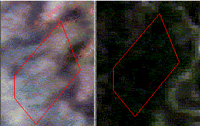
According to the photointerpretation of the true colour composite 3, 2, 1 Landsat 5 TM of 26.06.1993, the area delineated by the red polygon appears to be of homogeneous land use on the right photo. The same area appears to be of heterogeneous land use on the forest map (left photo), probably due to the differentiation in vegetation’s spectral signatures through time and atmospheric conditions.


Left.GIF (643 bytes)  Up.GIF (417 bytes)  Right.GIF (612 bytes)