


|
Landslides constitute natural phenomena with catastrophic consequences for the natural and man-made environment. Understanding of the phenomenon is very important for the prediction and the selection of suitable protection measures.
Landslides are among the most important natural hazards and they are the result of the reduction of stability of soil and rock slopes.
Too many combined factors act in order for the slope to transmit from the limit equilibrium state to the failure. The factors that contribute to the development of landslides include the preparatory causal factors, which cause the reduction of the slope stability and the triggering causal factors which cause the initiation of the mass movement.
Seismic action and rainfall are contribute in both ways and act either for a long-time period or periodically.
Hazard estimation of landslides is a very difficult task due to the complexity of the natural system itself and the difficulty in determining the necessary input data for the analysis.
|


|
HELLENIC REPUBLIC MINISTRY OF NATIONAL EDUCATION AND RELIGIOUS AFFAIRS
OPERATIONAL PROGRAM FOR EDUCATIONAL AND VOCATIONAL TRAINING II (EPEAEK II) |
|
EUROPEAN UNION
EUROPEAN SOCIAL FUND |
|
The purpose of the investigation is to find the best correlation models between the landslide hazard and the intensity of rainfall and seismic action.
The research is conducted using methods of informatics and computer mechanics.
The main scope is the knowledge extraction through data mining, as well as the investigation for the contribution of the parameters of seismic action and rainfall, using Artificial Neural Networks (A.N.N.).
Monitoring of selected locations of active landslides, using satellite (GPS) and terrain geodetic methods, will be part of the research.
Geographic Information Systems (GIS) will be used, as they will offer the interface and the appropriate environment in order to couple the results from different phases of the research in order to develop realistic landslide hazard maps. |
|
“PYTHAGORAS II -
“Program on Environmental Protection and Environmental Training” |
|
THE INFLUENCE OF SEISMIC ACTION AND RAINFALL IN LANDSLIDE PHENOMENA - INVESTIGATION USING METHODS OF INFORMATICS
LABORATORY OF STRUCTURAL MECHANICS AND TECHNICAL WORKS
SCHOOL OF RURAL AND SURVEYING ENGINEERING |
|
CENTER FOR THE ASSESSMENT OF NATURAL HAZARDS AND PROACTIVE PLANNING |
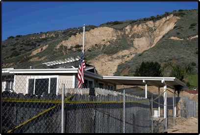
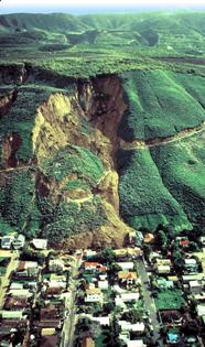
Landslide in La Conchita area, California, January 10, 2005, By Randall W. Jibson |
|
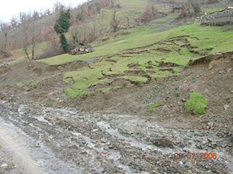
Cases of ground erosion in Karditsa county. Erosion of river bank (Winter of 2003-2004). |
|
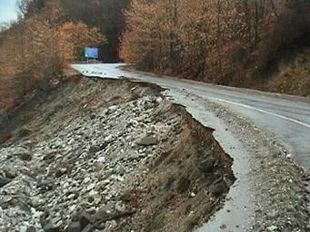
Landslides on the road Sarantaporo—Neraida, Karditsa county (Winter 2004-5). Photos have kindly granted by Mr. Dimitrios Tsoukis, Engineer in the prefecture of Karditsa. |