 |
|
![]()
The second part of the process is :
These districts are defined as pieces of the urban area delimited by the wide thoroughfares (wide streets, railways and rivers). To segment the image according to the wide thoroughfares, the previous classification is mixed with an edge detection algorithm.
As already said, the wide thoroughfares appear as dark straight lines of one to three pixels of thickness (dependent on the image type: XS or P+XS) on the third band. They represent valley type edges. To extract this type of edges, ISEF filter is performed (ISEF is also an optimal filter for valley edge detection [J. Shen, 1993b]).
There are different widths of streets, railways and rivers. So, the filtering coefficient must be tuned according to the thickness of the lines to be extracted. The extraction of narrow streets needs a lower filtering coefficient than the extraction of wide streets. In our case, focus is on wide streets, railways, and narrow rivers. Of course, the filtering coefficient is also dependent on the image resolution (XS or P+XS).
To extract the edges, the zero crossings of the first derivative in the eight directions are studied, according to the maximum value of the second derivative:
Then, a hysteresis-based threshold on the second derivative value eliminates wrong edges. Only are kept chains of pixels for which
These thresholds are chosen interactively but are approximately the same for each new image taken in the same conditions. This step provides an image of valley edges.
Now, have to be kept those which belong to the thoroughfare class: streets,
rivers, and railways. So, must only been kept the edges which belong to
classes C1 or C2:
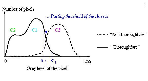
A threshold must be chosen according to the threshold between class C3 and class C1. A hysteresis based thresholding method on the gray level allows well-connected edges to be obtained.
The threshold values are defined by the previous classification result. Only are kept chains of pixels with all gray level lower than a threshold S'1 and with at least, one gray level lower than another threshold S'2.
S'1 and S'2 are computed according to the value of the threshold between class C3 and class C1 previously defined:
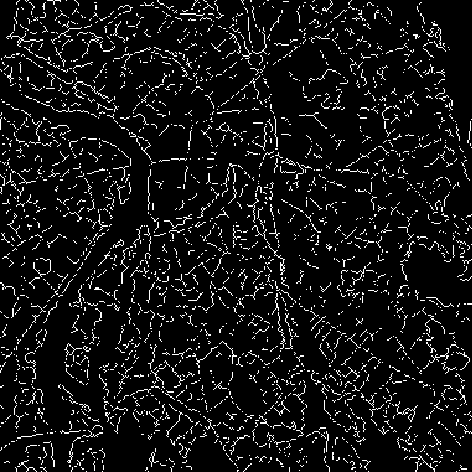
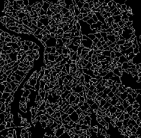
The result is a set of opened chains (Figure 68) that belong to the thoroughfare class (streets, railways, and rivers).
 |
Now, edges must be closed to obtain the regions of the urban area.
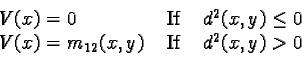
The opened chains are extended, according to the direction of the chain extremity, with the use of a backtracking method that manages with the value of the second derivative, weighted by a membership coefficient (m12) of the pixel to the class C1/C2:
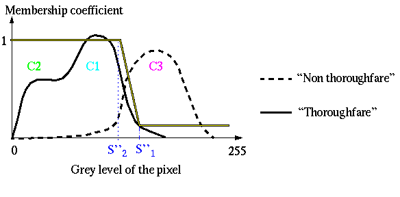
The values of S''1 and S''2 are defined according to the values of S'1 and S'2 previously computed. The value of the membership coefficient (m12) is always greater than zero so all chains will be closed in the best direction. Like S'1 and S'2, these thresholds are approximately the same for each new image taken in the same conditions.
The final value used to close the chains is:
 |
d2(x, y): Maximum of the values of the four second derivatives of the pixel (x, y) m12(x, y):Membership coefficient of the pixel (x, y) to the thoroughfare class.
The method used to close the opened chains is based on A* algorithm.
First of all, the direction of the opened chain is computed at the chain
extremity (with at the most four pixels). This direction allows an interval
of directions to be detected, where must be situated the direction of the
added pixels:
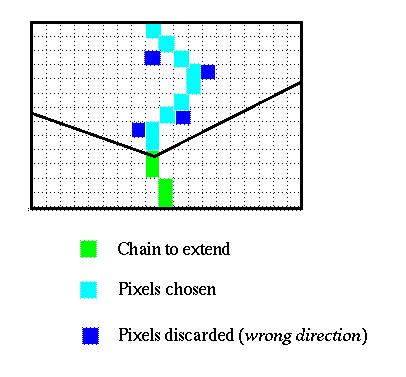
To extend the chain, its direction at the current extremity is considered. The edge direction defines five candidates which could extend the chain. For each candidate pixel, are examined
If one of these parameters is out of the limits defined by the user, the candidate pixel is rejected:
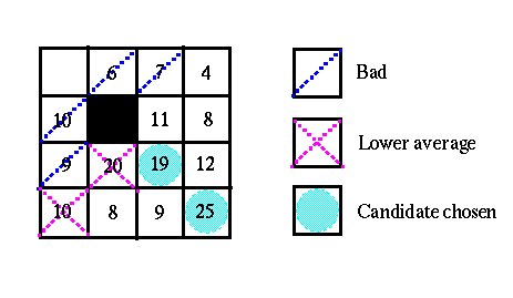
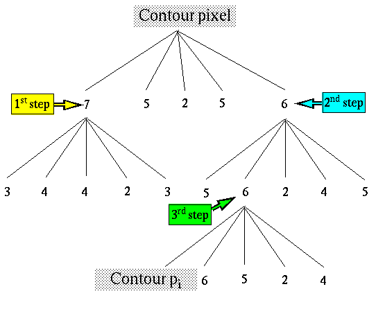
Else, the pixel is added to the ordinate list of the candidate chains extremities according to the average value of the added chain it belongs to. Finally, the `` father '' pixel of the candidate pixels is eliminated from the list and the new best pixel of the list (the first element) is chosen to extend the opened chain. This is an example of closing, represented as a tree:
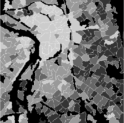
The result of this closing step, is a set of regions (Figure 69).
 |
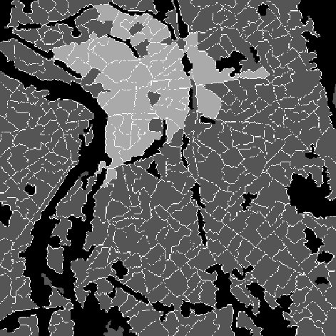
If a resulting region is too small to define an urban district (noise), it is merged with one of its neighbours, according to its average gray level in the third band and the contrast of their boundary.
Finally, the resulting regions are labeled with the density of pixels that belong to the street class in the region. Then, thresholds are selected to define different levels of urban density. On the image (Figure 70), three thresholds have been defined interactively. To obtain a pure image of densities, the contours of the regions can be discarded. These pixels belong to thoroughfare class including the street class and so, can be aggregated with the densest region they delimit.
 |
In order to be extracted, the city center must be defined. It is the biggest group of neighbouring regions such as
These thresholds can be adjusted according to the definition of the city center (minimal density). A hysteresis based thresholding method is applied on the urban density of the regions.
 |