|
|
| Photorecognition Elements |
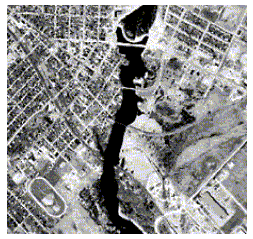
This is an example of identifying different features on an image, according to their photorecognition elements. It is based on an exercise of the CCRS’s 1998 tutorial. The features identified are: race track, river, roads, bridges, residential area, open/forested/rural areas and dam. |
|
race track: characteristic shape river: contrasting tone and shape roads: shape and bright tone bridges: shape, tone and association with the river residential area: pattern (individual houses as dark and light tones) open forested/rural areas: tone, size, texture and shape dam: contrasting tone with the river, shape and association with the river |
| Resolution |
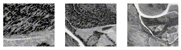
Four types of resolution are used to describe remotely sensed images: spatial, spectral, temporal and radiometric. Spectral resolution refers to the dimension and number of specific wavelenght intervals in the electromagnetic spectrum to which a sensor is sensitive. Temporal resolution of a sensor refers to how often a given sensor obtains imagery of a particular area. Radiometric resolution defines the sensitivity of a detector to differences in signal strength as it records the radiant flux reflected or emitted from the terrain. (Jensen, J. "Introductory Digital Image Processing", 1986). Spatial resolution refers to the discernible detail in the image. Images with relatively small ground pixel sizes are referred to as high spatial resolution images. As an example, you may see the three remotely sensed images of the Chena River in Fairbanks (Alaska) taken simultaneously, and note that as spatial resolution decreases, the area covered by the image increases. |
High spatial resolution image Medium spatial resolution image Low spatial resolution image |
(Verbyla et al. in “Processing Digital Images in GIS”, 1997) |
| Pre - processing of digital remotely sensed images |
Radiometric corrections |
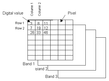
| The
satellite image consists of a number of pixels ordered into rows and columns.. Each pixel
holds a number of radiometric values representing the intensity of the reflectance of each
band. This is illustrated here by representing each band by a sub image. |
|
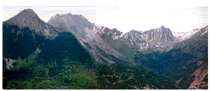
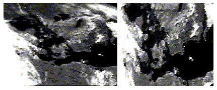
A radiometric correction adjusts for variations in the radiance received across the image caused by the scanner itself and atmospheric effects. However, radiometric correction is only possible to a certain extent. The reflectance from totally shaded surfaces generally consists of a mixture of noise and scattering from the atmosphere and the surrounding pixels. Effects of shadows are caused by relief or by the various types of surface cover. For example, as shown below, in mountainous areas the slopes facing the sun will receive more sunlight and thus have a higher reflectance than others, which can in some extent be corrected by computer manipulation. |
Photo: Metsovo Province (Greece) |
|
Geometric corrections |
This is an example of a geometrical rectification: Denmark and south Sweden seen from METEOSAT before and after processing: |
|
| Image Source
SCION, 1998 |
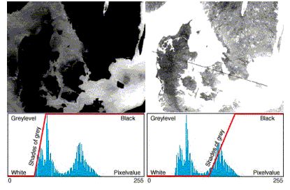
| Image Enhancement |
Contrast Enhancement |
|
Image Source: SCION, 1998 |
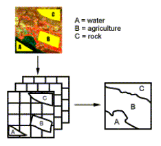
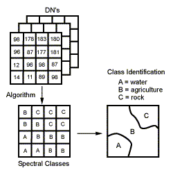
| Image Classification |
Schematic representation of the supervised classification procedure |
| CCRS, 1998 |
|
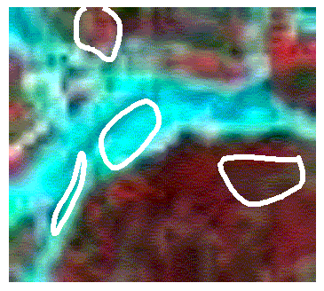
Example of training polygons overlayed on a
Spot |
Schematic representation of the unsupervised classification procedure |
| CCRS, 1998 |
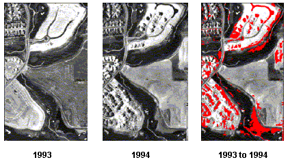
| Remote Sensing Methodology Applications |
Change Detection for Environmental Monitoring For example, if we want to examine
what changes have taken place over a one-year period in an area under development, we can
perform automated change detection. As shown below, using high-resolution imagery (e.g.
panchromatic images) and a special algorithm to perform the analysis, we can easily and
quickly observe urban development changes, which have occurred within this time period: |
|
Red shading in the third image indicates features that have been added to the area between 1993 and 1994, including the addition of housing developments, roads, landfills and other cultural features. Source: Space Imaging, 1998 |
| In forestry applications, a previous knowledge of
the basic issues concerning the characteristics of forest areas is a valuable tool in
developing the appropriate specific methodology. The contribution of the specialized
forester (and photointerpreter) is very important for conducting a remote sensing
investigation in these areas. The forester needs to be informed on the rapidly changing
remote sensing methodologies and techniques, in order to perform the investigation. Since
this is not always possible, an interdisciplinary cooperation is often required. As an
example, for the photointerpreter forester, being aware of the photosynthesis procedure
but limited by the use of panchromatic imagery, it is especially difficult to distinguish
a military installation covered by leaves, since panchromatic imagery senses a broad range
of all visible wavelengths and is not as sensitive to vegetation differences. For the
photointerpreter being aware on new techniques on false color imagery, it is possible to
determine differences in the photosynthesis procedure, but there are still difficulties in
explaining the whole mechanism. To develop the specific methodology appropriate for each case, systematic collaboration between the forester and the expert photointerpreter is therefore necessary. |
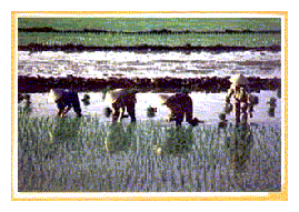
| For example, when monitoring areas where rice
plantations exist, the analyst should take into consideration that rice plantations are
covered by water (as shown on the picture below) and therefore a different spectral
signature is obtained, confusing the interpretation process. |
|
Photo from the project: Monitoring the Red River delta environment (Vietnam) |
| (Joint project: CARTEL & VTGEO) |
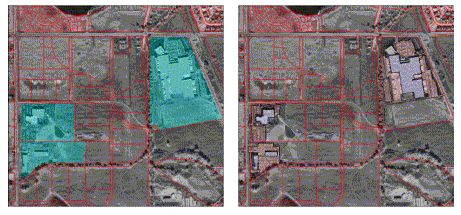
High-resolution imagery in Urban Planning |
|
High-resolution imagery in combination with line-drawn maps is a valuable tool for planning future development, including monitoring urban growth and the environment, as well as planning utility networks. On the left image, a combination of residential and industrial property is revealed. On the right image, planners can easily determine the value of residential properties based on their proximity to the industrial park, or which parcels are still available for development based on the terrain. On the same photo, commercial properties (in blue) that have been developed but not fully utilized are also revealed, helping planners determine expansion areas. Source: Space Imaging, 1998 |
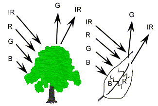
| A chemical compound in leaves called chlorophyll strongly
absorbs radiation in the red and blue wavelengths but reflects green wavelengths. Leaves
appear "greenest" to us in the summer, when chlorophyll content is at its
maximum. In autumn, there is less chlorophyll in the leaves, so there is less absorption
and proportionately more reflection of the red wavelengths, making the leaves appear red
or yellow (yellow is a combination of red and green wavelengths). The internal structure
of healthy leaves acts as an excellent diffuse reflector of near-infrared wavelengths. If
our eyes were sensitive to near-infrared, trees would appear extremely bright to us at
these wavelengths. In fact, measuring and monitoring the near-IR reflectance is one way
that scientists can determine how healthy (or unhealthy) vegetation may be. |
|
CCRS, Tutorial, 1998 |
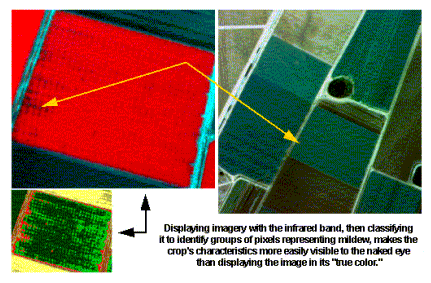
Since measuring and monitoring the near-IR reflectance is one way to determine how healthy (or unhealthy) vegetation is, we can easily detect crop diseases (for example mildew), by using the infrared band. As illustrated in the above high-resolution image displayed with the infrared band, crop characteristics are more easily visible than when displayed in true color. |
|
Image source: Space imaging, 1998 |
 |
National Technical University of Athens |