|
Data Used & Project Outline
It is based on the CORINE Land Cover nomenclature and database.
It uses satellite images, such as SPOT, LANDSAT TM, LANDSAT MSS, topographic maps, thematic maps, aerial photographs, etc.
The LACOAST Project is divided into the 2 following Workpackages:
Workpackage I
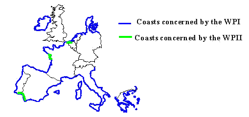
Workpackage I consists in a quantitative analysis of changes in Land Cover over a 10-km wide coastal strip around the countries of Europe.
It is done through a comparison of the CORINE Land Cover Level 3 database (44 Land Cover classes-scale: 1/100,000) of 1987-1990 with the LANDSAT MSS satellite images of 1975, and the creation of a Land Cover database for the year 1975.
This Workpackage is concerning only the countries/coasts where CORINE LC is presently completed and Greece.
Workpackage II
Workpackage II consists in an exhaustive study of three selected zones of specific interest:
The main objective is the comparison of CORINE Land Cover Level 4, 5, 6 database (nomenclature and scale refined), with data for 4 dates: 1955, 1975, 1985 and 1995. This data is SPOT, LANDSAT TM and LANDSAT MSS satellite images and aerial photographs.
Greece participates in the Workpackage I and studies the Land Use/Land Cover changes for the zone of 10km along the shoreline of the mainland of Greece, Peloponnisos and Crete. The Company responsible for the Project is KTIMATOLOGIO S.A.
The Project is carried out in the following different stages:
|
