Introduction to Photointerpretation
and Remote Sensing
|
1.1 Concepts and Definitions
1.2 Object of Photointerpretation and Remote Sensing
1.3 Applications of Photointerpretation and Remote Sensing
1.4 Imagery used for Photointerpretation purposes
1.5 Parameters influencing aerial photograph acquisition
1.6 Platforms
1.7 Human beings and Remote Sensing Systems. Possibilities and Constraints
| 1.1 Concepts and Definitions |
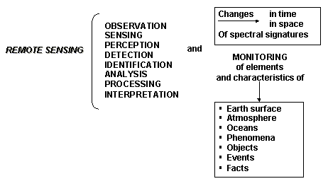
Photointerpretation is the methodology for acquiring information from photograms or stereopairs. It was developed in parallel with Photogrammetry, and is the first application of remote sensing familiar to human beings, in the sense that photograms and stereoviews constitute an analogical optical-mechanical and photochemical equivalent to the sensitivity of the eye to visible light, optical perception and stereoscopic vision. Reference: Rokos, D. “Photointerpretation and Remote Sensing”, NTUA, 1979 |
Reference: |
|
| 1.2 Object of Photointerpretation and Remote Sensing |
Photointerpretation’s prime objective is the intensive and orthological use of air photograms (more than of terrestrial ones) for the acquisition and exploitation of information, concerning all scientific and technical fields that require knowledge of multiple elements, prototypes, conditions, preconditions and parameters of the physical and socio-economic reality of an area. Therefore, planning of construction works, monitoring a system or a phenomenon, or even managing a development project at a state or regional level, can rely on the above-mentioned elements. Reference:.Rokos, D. “Photointerpretation and Remote Sensing”, NTUA, 1979
|
| 1.3 Applications of Photointerpretation and Remote Sensing |
|
|
Reference:.Rokos, D. “Photointerpretation and Remote Sensing”, NTUA, 1979
|
| 1.4 Imagery used for photointerpretation purposes |
|
| the most
widely used in photointerpretation applications are the aerial photographs; that means
images taken from an aircraft carrying a photogrammetric camera with a perpendicular or an
inclined optical axis. We are using terrestrial photographs on special occasions, but, since 1972, there has been increasing use of satellite images for photointerpretation applications in the exploration of natural resources etc. (LANDSAT, SPOT, SOYUZ, MOS Programmes). Although images with an inclined optical axis give us an aspect of the ground more familiar to our sight, we generally use images with a perpendicular optical axis. In any case, the parallel and complementary exploitation of perpendicular/inclined images is particularly useful if they are available or can be taken during field surveys. Aerial photographs with a perpendicular optical axis are taken with the already known photogrammetric cameras, which have the following characteristics: |
| a. Focal distance f = 88 mm, f = 152 mm and f = 305 mm and photograph dimensions 23 cm X 23 cm and |
| b. Focal distance f = 70 mm, f = 115 mm and f = 210 mm and photograph dimensions 18 cm X 18 cm. |
Photogrammetric cameras 70/18 and 88/23 are called ultra wide-angle cameras,
because their field of view is 1200 – 1390. Reference:.Rokos, D. “Photointerpretation and Remote Sensing”, NTUA, 1979
|
| 1.5 Parameters influencing aerial photograph acquisition |
|
|
Reference:.Rokos, D. “Photointerpretation and Remote Sensing”, NTUA, 1979
|
| 1.6 Platforms |
Reference: C.P.Lo., “Applied Remote Sensing”, University of Georgia.
|
| 1.7 Human beings and Remote Sensing Systems. Possibilities and Constraints |
The human eye, like the photographic camera, converts the differences/changes of the reflective/emissive radiation to tone/shade/ colour differences. Both the human eye and the camera register space in detail and in a geometrical integration. On the other hand, remote sensing scanners, being more expensive than cameras and having a more complicated structure convert the differences/changes of the reflective/emissive radiation into electrical signals. The human eye is limited as a remote sensor because of: |
| In the
process of analysis and interpretation of remotely sensed images, the well- trained
specialist photointerpreter, has significant insurmountable advantage against any machine,
because of his superior intelligence in evaluating, in an integrated way, the qualitative
and quantitative characteristics of the objects/facts/ phenomena/ events/appearances/etc.
of the natural and socioeconomic reality. Reference: Rokos, D. “Photointerpretation and Remote Sensing”, NTUA, 1979 |
 |
National Technical University of Athens |