Deceti.jpg (13851 bytes)

MoreLeft.GIF (555 bytes)

Left.GIF (643 bytes)


Results


By combining the supervised classification data of Landsat 5 TM 24.06.1993 with a digital elevation model, different perspective views of the area are obtained:


12-10.gif (33952 bytes)

12-11.gif (18320 bytes)

12-12.gif (23829 bytes)


Flying over the above model was also possible, using the 3d Viewer module of ER-Mapper.


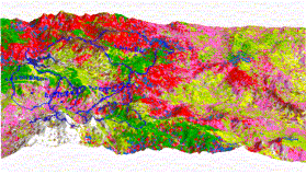
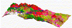
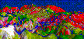
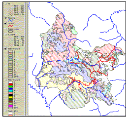
Finally, the hardware and software of the System developed by the Laboratory of Remote Sensing of the NTUA gives the possibility of data integration, taking advantage of the appropriate combinations and correlation of all the existing data, information layers, pictures, digital elaboration and maps etc., on a unique and accurate geodetic reference system, so that to secure the best possible integration of the analogical and digital remote sensing and multimedia methods and techniques in a Geographical Information System environment.


12-13.gif (23921 bytes)


A combination of the DTM data with the road network and the rivers of Metsovo Province.


See also: “Structuring an Integrated Information System for Development and Environment of the Metsovo Province”, “Evaluating the quality and accuracy of classification methods of corrected or not from relief effects SPOT XS imagery of the Metsovo province” full paper in Greek and “Comparing the quality and accuracy of SPOT and Landsat imagery classifications of the Metsovo Province”, abstract, also in Greek.


Up.GIF (417 bytes)