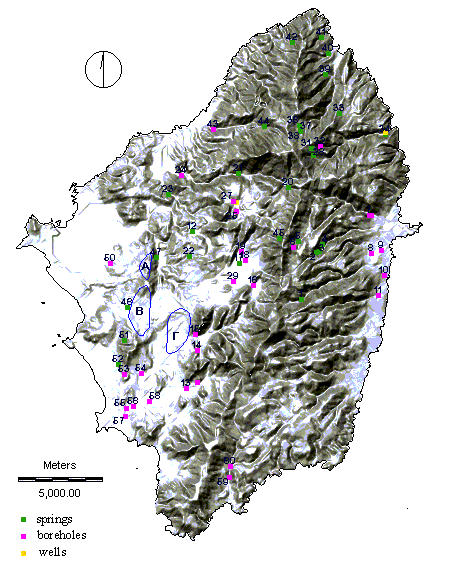
|
ID
|
Name
|
Community
|
Type of spring
|
Min-Max Discharge
m3/h
|
Aquifer
|
Notes
|
| 1 |
Danakoss |
Danakos |
Karstic |
10 - 30 |
mr |
Possibly
related to fracture zone. |
| 2 |
Provolakion |
Apeirathos |
Karstic |
5 - 60 |
mr |
Possibly
related to fracture zone. |
| 3 |
- |
Apeirathos |
Karstic |
5 - 20 |
mr |
Possibly
related to fracture zone. |
| 4 |
Katefora |
Apeirathos |
Karstic |
5
- 8 |
mr |
. |
| 5 |
Zakrida |
Apeirathos |
Contact |
5 - 8 |
sch |
Possibly
related to fracture zone. |
| 12 |
Flerio |
Melanes |
Karstic |
~
40 |
mr |
- |
| 17 |
Ag. Marina |
Halki |
Karstic |
10 -15 |
mr-sch |
Affected
or depleted by nearby borehole (brh18). |
| 20 |
Keramotis |
Keramoti |
Karstic |
5 - 20 |
mr-sch |
Affected
or depleted by nearby borehole. |
| 21 |
Garinos |
Kinidaros |
Contact |
20 - 35 |
mr-mg |
Possibly
related to fracture zone. |
| 22 |
Potamias |
Potamia |
Karstic |
10 - 30 |
mr |
Possibly
related to fracture zone. |
| 23 |
Kouradis |
Melanes |
Karstic |
4 - 8 |
mr |
- |
| 28 |
Koronoss |
Koronos |
Karstic |
5 - 40 |
mr |
Possibly
related to fracture zone. |
| 31 |
Skados |
Skado |
Contact |
5 - 10 |
sch |
- |
| 33 |
Mesis |
Mesi |
Karstic |
2 - 5 |
mr |
- |
| 34 |
Lionas |
Koronos |
Karstic
bourne |
0 - 40 |
mr |
- |
| 36 |
Komiakis
1 |
Koronis |
Contact |
3 - 6 |
sch |
- |
| 37 |
Komiakis
2 |
Koronis |
Contact |
3 - 6 |
sch |
- |