This example shows how Remote Sensing and
GIS methods and techniques may be used in hydrogeological exploration. It is based on a
research project carried out by the Remote Sensing Laboratory of NTUA, Greece.
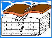
Groundwater is by definition subterranean.
Most Remote Sensing methods and techniques have no penetrating capabilities beyond the
uppermost layer. However, satellite imagery can be a valuable asset in the early stages of
groundwater exploration.
Vast areas of the world consist of hard
rocks (basement complexes) or limestone terrain, where water is restricted to secondary
permeability. In this example, lineaments and "fracture traces" recognized on
enhanced TM images, are used to try to identify target drilling sites for groundwater
exploration.