 |
|
![]()
Map of Areas Favourable to each Class
![]()
Production rules describe the most favourable geographical context to each class, and allow a certain degree to be assigned to each pixel of the image. This degree evaluates how much the context is favourable to the presence of each class.
Desachy, Zahzah and Mascarilla calculated these degrees using various techniques:
For example, about a given class c, the neural network calculates that all the samples are between 800 meters and 1000 meters of altitude, that often they are located near towns.... ``Often'' means that 80% of the pixels of the samples are in this case.
The production rules generated are then used to build an ``ideal'' theoretical card of distribution of each class in the image. This training technique of production rules from samples, was developed to allow the expert to improve the rules which he proposed. In effect, the real geographical context of samples of a class, and its production rules may sometimes contradict each other.
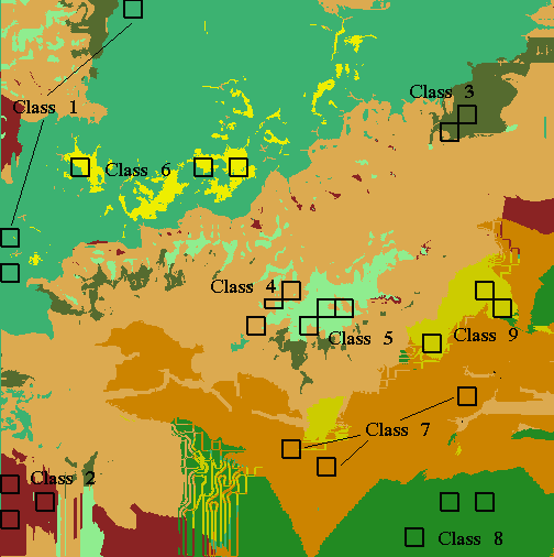
We will use here the image of the areas favourable to each class calculated by Mascarilla. This image is the more in accordance with the samples. It allows areas to be defined, which include the samples around 95.50% . The image 5 presents these areas favourable to each class and the localization of the samples.
This map of favourable areas provides information of a level higher than that of the spectral bands and out-image data. It is about the result of a argument carried out for each class. In this way, the information is more reliable than those provided by the spectral bands or out-image data.
However, this information is incomplete. It is a theoretical distribution of the classes in the image. It is necessary to supplement it using the spectral information brought by the spectral bands which contain the information on the real localization of the classes. That is the subject of "Fusion by priority".